Destineo
Contains ads
50K+
Downloads

Everyone
info


About this app
Destineo simplifies your travel in Pays de la Loire.
This application allows you to calculate routes, consult timetables in all circumstances, check the traffic situation and discover the transport options around you.
All the essential solutions in your pocket:
- Calculation of routes for an imminent or delayed departure. Destineo offers you the best routes for your trip by combining public transport (bus, train, tram, etc.), walking, personal bicycle, self-service bicycle, personal vehicle, carpooling.
- Visualization of a route and associated stops
- Consultation of your network timetables by line and stop.
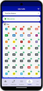
- Information on current or future disruptions.
- Display of nearby transport options (bus stops, bike stations, bike shelters, etc.).
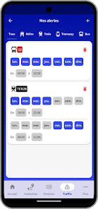
- Saving favorites to simplify daily searches.
Associated transport networks:
- Angers Loire Métropole, IRIGO
- Pays de la Loire region: Aléop car, TER and boat
- Les Sables d’Olonne Agglomération, Oléane
- CARENE (Agglomeration Community of St Nazaire), Stran
- Choletais Agglomeration Community, Choletbus
- Laval Agglomération, TUL
- La Roche sur Yon Agglomération, ImpulsYon
- Le Mans Métropole, Setram
- Nantes Métropole, Naolib
- Guérande Peninsula, Lila Presqu’Île
- Sablé-sur-Sarthe, Réso
- Saumur Val de Loire, Ogalo
- SNCF, TGV and Intercités
- Nantes Atlantique Airport
- Structuring lines of the IDFM network in the Paris region
This application allows you to calculate routes, consult timetables in all circumstances, check the traffic situation and discover the transport options around you.
All the essential solutions in your pocket:
- Calculation of routes for an imminent or delayed departure. Destineo offers you the best routes for your trip by combining public transport (bus, train, tram, etc.), walking, personal bicycle, self-service bicycle, personal vehicle, carpooling.
- Visualization of a route and associated stops
- Consultation of your network timetables by line and stop.
- Information on current or future disruptions.
- Display of nearby transport options (bus stops, bike stations, bike shelters, etc.).
- Saving favorites to simplify daily searches.
Associated transport networks:
- Angers Loire Métropole, IRIGO
- Pays de la Loire region: Aléop car, TER and boat
- Les Sables d’Olonne Agglomération, Oléane
- CARENE (Agglomeration Community of St Nazaire), Stran
- Choletais Agglomeration Community, Choletbus
- Laval Agglomération, TUL
- La Roche sur Yon Agglomération, ImpulsYon
- Le Mans Métropole, Setram
- Nantes Métropole, Naolib
- Guérande Peninsula, Lila Presqu’Île
- Sablé-sur-Sarthe, Réso
- Saumur Val de Loire, Ogalo
- SNCF, TGV and Intercités
- Nantes Atlantique Airport
- Structuring lines of the IDFM network in the Paris region
Updated on
Safety starts with understanding how developers collect and share your data. Data privacy and security practices may vary based on your use, region, and age. The developer provided this information and may update it over time.

No data shared with third parties
Learn more about how developers declare sharing

This app may collect these data types
App activity, App info and performance, and Device or other IDs

Data isn’t encrypted
Data can’t be deleted
What's new
- Correction de bugs
- Retrait du mode de transport métro
- Retrait du mode de transport métro